
- Bookmark
- Share
- Leave a review
- Direct message
- Claim listing
- prev
- next
Description
Papamoa Hills Summit Track is a 3.7 kilometer out and back trail located near Te Puke, Bay of Plenty, New Zealand that features a great forest setting and is rated as moderate. The trail is primarily used for hiking, walking, and running.
This is a steep walk in Pāpāmoa Hills Regional Park that takes you through farmland to beautiful views of Mauao, Tauranga Harbour, and Whale Island at the dramatic summit. Bring plenty of water and a hat - there's not much shade along the way. The track is well-marked and provides different options to extend your walk or run.
Located in the Western Bay of Plenty, near Te Puke, Pāpāmoa Hills Cultural Heritage Regional Park is a 135 hectare property explored and enjoyed by thousands of visitors each month.
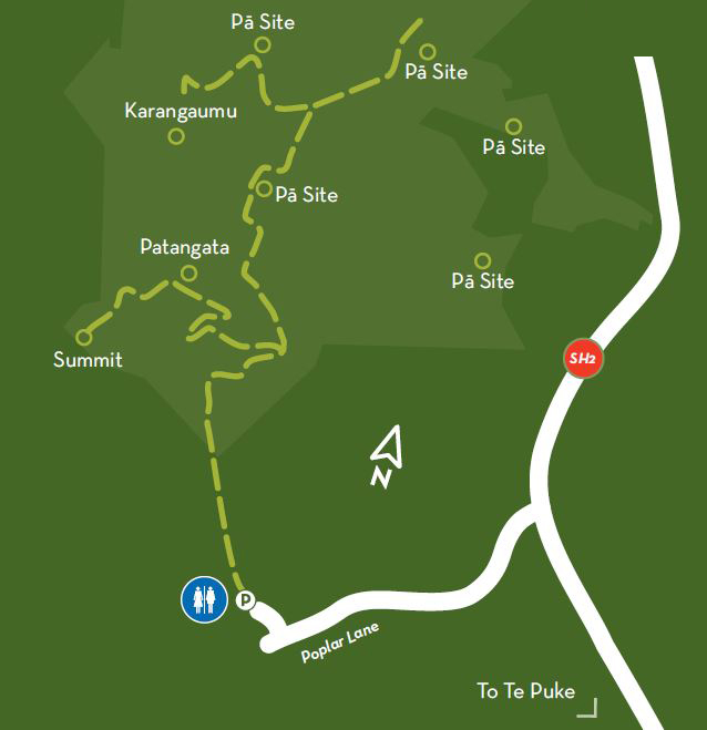
The summit is 224 metres above sea level and offers sweeping views of the Bay of Plenty coastline. There are several tracks through the park which can be used to enjoy the views and explore the numerous archaeological features, including seven pa sites.
Getting there
From Tauranga
20 kilometres - 20 minutes
Travel east on State Highway 2 towards Pāpāmoa. Take the Domain Road exit from State Highway 2.
Continue on Pacific Coast Highway/Te Puke Highway to Poplar Lane. Turn right into Poplar Lane.
From Rotorua
65 kilometers - 45 minutes
Take State Highway 33 from to Pacific Coast Highway/Te Puke Highway in Paengaroa.
Follow Pacific Coast Highway to Poplar Lane in Pāpāmoa. Turn left from State Highway 2 into Poplar Lane.
From Whakatāne
80km - 60 minutes
Follow State Highway 2 to Pacific Coast Highway/State Highway 30 near Paengaroa.
Follow Pacific Coast Highway to Poplar Lane in Pāpāmoa. Turn left from State Highway 2 into Poplar Lane.
Poplar Lane, off Te Puke Highway
17km south of Tauranga along the Te Puke Highway. You'll find the Papamoa Hills Regional Park at the end of Poplar Lane.
About the walk
One hour return
The main walking track is from the car park on Poplar Lane to the trig station (at 224m). This track rises fairly steeply and leads through native bush and open farmland. The main track showcases the terracing on several pā sites. The reward at the summit is a spectacular panoramic coastal view.
There are several other tracks which allow you to explore the cultural heritage of the park and make the most of the expansive views. Most tracks lead you to each of the six pā sites within the park boundary.
Although most tracks are well formed, good walking shoes are recommended, as is a reasonable level of fitness. Take a bottle of water with you as there is no drinking water supply in the park.
There is an information board in the car park that provides further information about using the park. The park is also an operational farm. Remember to always leave gates the way you found them.
Open hours: 6.30am - 7pm (winter); 6.30am - 9pm (summer).
The gate to the car park is locked overnight.
The park is managed by Bay of Plenty Regional Council.


Add a review